What Tools Are Used to Measure Tornadoes Effectively
Measuring tornadoes requires specialized instruments like Doppler radar, anemometers, and barometric sensors that track wind speed, pressure changes, and storm behavior. Meteorologists rely on these tornado measurement tools to issue timely warnings and save lives. Understanding how each device works helps us appreciate the science behind severe weather forecasting. This guide breaks down every major instrument used in tornado detection and measurement.
Key Takeaways
- Doppler Radar: The most important tool for detecting tornado formation and tracking storm movement in real time.
- Anemometers: Essential for measuring wind speed and gusts directly at ground level during tornado events.
- Barometric Sensors: Track rapid drops in atmospheric pressure that signal tornado development.
- Storm Chaser Equipment: Portable instruments deployed close to tornadoes for precise data collection.
- Emerging Technologies: New tools like phased-array radar and drones are revolutionizing how we measure tornadoes.
📑 Table of Contents
- How Tornadoes Are Measured
- Doppler Radar: The Eye in the Sky
- Anemometers: Measuring Wind Speed at Ground Level
- Barometric Sensors and Pressure Tools
- Storm Chaser Equipment: Getting Close to the Storm
- Emerging Technologies in Tornado Measurement
- Common Mistakes in Tornado Measurement
- Key Takeaways
- Conclusion
How Tornadoes Are Measured
Tornadoes are among the most destructive weather events on Earth. They form fast, strike hard, and leave devastation in their wake. But how do scientists actually measure these violent storms? The answer lies in a suite of specialized tools used to measure tornadoes that have been developed over decades of research and innovation.
Measuring a tornado is not like measuring rainfall with a simple gauge. It requires instruments that can capture extreme wind speeds, rapid pressure changes, and complex atmospheric dynamics. Meteorologists use a combination of ground-based tools, airborne devices, and satellite technology to get the full picture of a tornado’s power and path.
The tornado measurement tools we use today fall into several categories. Each one serves a specific purpose. Some tools detect tornadoes from far away. Others get dangerously close to collect precise data. Together, they form a network of observation that helps forecasters warn communities before a storm hits.
Understanding these tools also helps us appreciate how far weather science has come. What started with basic barometers and eyewitness reports has evolved into a high-tech system of detection. Let us dive into each category and see how these instruments work.
The Science Behind Tornado Measurement
Every tornado measurement tool relies on a core principle: collecting data about wind, pressure, and atmospheric conditions. Weather instruments have been refined over centuries, but tornado-specific tools are a more recent development. Scientists needed devices that could survive extreme conditions and still deliver accurate readings.
The Enhanced Fujita Scale is the standard system used to rate tornado intensity. It ranges from EF0 to EF5. To assign a rating, meteorologists need precise measurements of wind speed and damage patterns. This is where our tools come in. Without them, we would have no way to quantify the true power of a tornado.
Modern severe weather monitoring depends on multiple layers of detection. Satellites spot storm systems from space. Radar scans the atmosphere for rotation. Ground instruments measure what is actually happening at surface level. Each layer adds a piece to the puzzle. When all the data comes together, forecasters can paint a clear picture of a tornado’s behavior.
Doppler Radar: The Eye in the Sky
Doppler radar is the backbone of modern tornado detection. It works by sending out radio waves that bounce off particles in the atmosphere. When those waves return, the system analyzes them to determine the speed and direction of moving objects like rain, hail, and debris. This technology is absolutely critical for tornado detection.
The name “Doppler” comes from the Doppler effect, which describes how the frequency of a wave changes as it moves toward or away from an observer. Radar systems use this principle to detect rotation within thunderstorms. When radar shows a mesocyclone, which is a rotating updraft, it raises the alert level significantly.
How Doppler Radar Works in Practice
Doppler radar stations are positioned across the country in a network called NEXRAD, which stands for Next Generation Radar. These stations scan the atmosphere continuously. They can detect storm features at distances of up to 250 miles. The data they collect is processed in real time and sent to weather forecasting centers.
When a tornado warning is issued, Doppler radar is usually the first tool to flag the threat. It can identify rotation signatures that suggest a tornado is forming or already on the ground. However, radar has limitations. It cannot see what is happening at the surface. That is why ground-based tools are equally important.
Meteorologists also use weather radar in combination with computer models. These models simulate storm behavior based on current atmospheric data. The combination of radar observation and modeling gives forecasters the best possible chance of predicting where a tornado will touch down. It is a powerful system, but it still depends on the accuracy of the raw data from each instrument.
Anemometers: Measuring Wind Speed at Ground Level
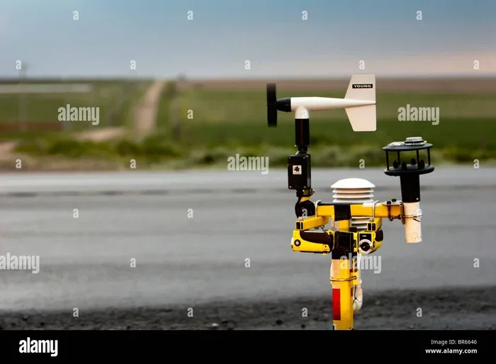
If Doppler radar watches from above, anemometers measure what is happening right at the surface. An anemometer is a device that measures wind speed. It is one of the most direct tornado measurement tools available. These instruments come in several designs, but they all serve the same basic purpose.
The most common type is the cup anemometer. It has three or four cups mounted on horizontal arms. As wind blows, the cups spin around a central axis. The faster the wind blows, the faster the cups rotate. A sensor counts the rotations and converts them into wind speed readings.
Types of Anemometers Used in Tornado Research
There are several types of anemometers used in meteorology. Each has its own strengths and limitations.
- Cup Anemometers: The most widely used design. They are reliable and durable. They work well in a range of wind conditions.
- Vane Anemometers: These measure both wind speed and direction. They use a propeller and a tail fin to align with the wind.
- Ultrasonic Anemometers: These use sound waves to measure wind speed without any moving parts. They are more delicate but very precise.
- Laser Doppler Anemometers: These use laser light to detect the speed of particles carried by the wind. They are used in research settings.
During tornado events, cup and vane anemometers are the most commonly deployed. They can withstand high winds and provide real-time data. However, most standard anemometers are destroyed by EF3 or stronger tornadoes. That is why researchers deploy ruggedized versions and try to recover data after storms pass.
Another important metric that anemometers help track is wind gusts. A sustained wind speed tells one story, but the peak gust can be far more destructive. Anemometers capture these short bursts of high-speed wind, which is essential for understanding the true impact of a tornado. Accurate wind speed data also feeds into the Enhanced Fujita Scale ratings that classify tornado intensity.
Barometric Sensors and Pressure Tools
Atmospheric pressure plays a huge role in tornado formation. A rapid drop in barometric pressure often signals that a severe storm is developing. Barometric sensors measure this pressure with high precision. They are a key part of the toolkit for measuring tornadoes.
These sensors work by detecting changes in air pressure at a given location. When a strong low-pressure system moves through, the sensor records the drop. Meteorologists look for sharp, sudden decreases in pressure as a sign that tornado conditions may be present.
How Pressure Data Helps Predict Tornadoes
Tornadoes tend to form in environments where there is a sharp contrast in pressure. Warm, moist air meets cool, dry air. The boundary between these air masses creates instability. Barometric sensors detect this instability early, giving forecasters more time to issue warnings.
Portable pressure sensors are also used by storm chasers. These devices are mounted on vehicles and can record pressure changes as a storm approaches. The data collected helps researchers understand the pressure dynamics that lead to tornado formation. It is some of the most valuable ground-truth information available.
In weather stations, barometric sensors are often paired with other instruments. Together, they create a complete picture of local atmospheric conditions. This integrated approach to severe weather monitoring ensures that no single data point is missed. Each sensor contributes to a larger, more accurate forecast.
Storm Chaser Equipment: Getting Close to the Storm
Storm chasers play a unique role in tornado research. They drive directly into the path of severe storms to deploy instruments and capture close-up observations. Their equipment is specially designed to survive extreme conditions and collect data that cannot be obtained any other way.
Storm chasers use a variety of portable meteorological instruments. These include mobile weather stations, pressure loggers, and high-speed cameras. Some chasers also deploy tornado probes, which are ground-level sensors placed directly in a tornado’s path. These probes can measure wind speed, pressure, humidity, and temperature at the point of impact.
The Role of Mobile Weather Stations
Mobile weather stations are essentially portable versions of the fixed stations found at airports and weather centers. They include anemometers, barometric sensors, thermometers, and hygrometers. All of these instruments are packed into a vehicle or a trailer that can be driven to a storm location.
These mobile stations are incredibly valuable because they provide data from locations that fixed stations cannot reach. A permanent weather station might be 50 miles from a tornado. A mobile station can be positioned just a few miles away, giving much more precise measurements. This proximity is crucial for understanding how tornadoes behave at close range.
Storm chasers also rely on airflow measurement devices similar to those used in air compressor systems. In fact, the principles of measuring airflow are shared across many fields. For example, understanding how to use an air compressor effectively involves many of the same concepts of airflow and pressure that meteorologists apply to weather instruments. The measurement of cubic feet per minute, or CFM, is relevant in both contexts. Researchers working on weather instrumentation sometimes even consult guides on optimizing CFM output to improve the accuracy of their airflow sensors. The maintenance and calibration of these sensors also draw from compressor knowledge, including understanding what type of oil an air compressor requires to ensure smooth, accurate operation of mechanical components in field equipment.
Tornado Probes and In-Situ Measurements
Tornado probes are perhaps the most dramatic tools in a storm chaser’s kit. These devices are placed on the ground in the expected path of a tornado. When a tornado passes over them, they record a wealth of data in a matter of seconds. The instruments are built to withstand extreme forces, though many are destroyed in the process.
Data from tornado probes has led to some of the most important discoveries in tornado science. For instance, probes have recorded wind speeds that were higher than what radar alone could estimate. They have also measured pressure drops that are far more extreme than previously thought. Every probe that survives and returns data is a scientific treasure.
Storm chasing is dangerous work, but the data it provides is irreplaceable. Each mission adds to our understanding of how tornadoes form, intensify, and dissipate. This knowledge directly improves the accuracy of tornado warnings and helps protect communities in the path of future storms.
Emerging Technologies in Tornado Measurement
The field of tornado measurement is constantly evolving. New technologies are making it possible to collect better data faster and from safer distances. Researchers are always looking for ways to improve tornado detection and reduce the risk to both forecasters and the public.
Phased-Array Radar
Phased-array radar is an exciting new development in weather observation. Unlike traditional Doppler radar, which uses a single rotating dish, phased-array radar uses a flat panel with many small transmitters. This allows it to scan the atmosphere much faster. Faster scanning means more timely warnings when a tornado is forming.
Traditional radar takes about 4 to 6 minutes to complete a full scan. Phased-array radar can do the same scan in under a minute. That difference can be critical during a severe weather event. Every extra minute of warning gives people more time to seek shelter.
Drones and Unmanned Aerial Vehicles
Drones are opening up new possibilities for tornado research. They can fly into the environment around a tornado without putting human lives at risk. Equipped with sensors and cameras, drones capture data from altitudes and locations that would be too dangerous for storm chasers.
Researchers are also experimenting with drones that can deploy sensors into the path of a tornado. These flying sensors would collect data as they are carried by the storm and then transmit it back to a base station. The technology is still in development, but it holds great promise for the future of storm tracking.
Satellite-Based Measurement Systems
Weather satellites provide a bird’s-eye view of storm systems. They use a variety of sensors to detect cloud patterns, temperature differences, and moisture levels. While satellites cannot measure wind speed directly, they can identify the atmospheric conditions that favor tornado formation.
New satellite technologies are improving the resolution and frequency of these observations. Geostationary satellites can image the same area every few minutes. Polar-orbiting satellites provide more detailed data but less frequent coverage. Together, they give forecasters a comprehensive view of developing storm systems.
Machine Learning and Data Fusion
Artificial intelligence is making its way into tornado measurement. Machine learning algorithms can analyze vast amounts of data from multiple instruments and identify patterns that humans might miss. These systems can also predict tornado behavior with greater accuracy by learning from past events.
Data fusion is another powerful approach. It combines data from radar, anemometers, satellites, and ground sensors into a single unified model. This holistic view gives forecasters a more complete understanding of a tornado’s structure and potential impact. As these technologies mature, they will make tornado warnings faster and more reliable.
Common Mistakes in Tornado Measurement
Even with advanced tools, mistakes can happen in tornado measurement. Understanding these pitfalls helps researchers and forecasters improve their methods.
- Relying on a single data source: No one instrument tells the whole story. Radar might show rotation, but only a ground sensor can confirm a tornado is on the ground.
- Ignoring pressure data: Many forecasters focus on wind speed and overlook barometric readings. Pressure drops are often the earliest sign of tornado formation.
- Using uncalibrated instruments: Sensors that have not been properly calibrated can give inaccurate readings. This can lead to underestimating or overestimating tornado intensity.
- Deploying equipment too late: Timing is everything in tornado research. Instruments deployed after a tornado has passed miss the most critical data.
Key Takeaways
- Doppler Radar is Essential: It provides the foundation for tornado detection and tracking across large areas.
- Anemometers Measure Surface Winds: They give direct readings of wind speed and gusts at ground level.
- Barometric Sensors Detect Pressure Changes: Rapid pressure drops are key indicators of tornado development.
- Storm Chaser Equipment Fills the Gaps: Mobile stations and tornado probes collect data that fixed instruments cannot.
- New Technologies Are Transforming the Field: Phased-array radar, drones, and AI are making measurement faster and safer.
- No Single Tool Is Enough: A combination of instruments working together provides the most accurate picture.
Conclusion
The tools used to measure tornadoes have come a long way. From Doppler radar scanning the skies to anemometers standing guard at ground level, each instrument plays a vital role. Barometric sensors detect the pressure changes that signal danger. Storm chasers brave the elements to collect irreplaceable close-range data. And emerging technologies like phased-array radar and drones promise to make measurement even better in the years ahead.
Understanding these tornado measurement tools is not just for scientists. It helps everyday people appreciate the complexity of severe weather forecasting. When you hear a tornado warning on the news, know that a whole network of instruments and experts worked together to get you that alert. The data from these tools saves lives every single day.
The next time a storm rolls in, take a moment to think about the invisible web of measurement that is working to keep you safe. From the radar dome on the hill to the cup anemometer in the field, each instrument is a piece of the puzzle. Together, they give us the best possible chance of knowing what a tornado is doing and where it is going.
Frequently Asked Questions
What is the most important tool for measuring tornadoes?
Doppler radar is widely considered the most important tool. It can detect tornado formation from hundreds of miles away by identifying rotation within thunderstorms. However, it works best when combined with ground-based instruments like anemometers and barometric sensors.
Can anemometers survive a strong tornado?
Most standard anemometers cannot survive an EF3 or stronger tornado. They are destroyed by the extreme winds. However, researchers use ruggedized versions and deploy them strategically to capture data before the storm arrives. The data collected, even from destroyed instruments, is still valuable.
How do barometric sensors help predict tornadoes?
Barometric sensors detect rapid drops in atmospheric pressure, which often precede tornado formation. A sharp pressure drop signals that a storm is intensifying and that tornado conditions may be developing. Forecasters use this data alongside radar and wind measurements to issue timely warnings.
What is a tornado probe and how does it work?
A tornado probe is a ground-level sensor deployed by storm chasers directly in a tornado’s path. It measures wind speed, pressure, humidity, and temperature as the tornado passes over it. The probe is built to withstand extreme forces, though it is often destroyed in the process. The data it collects is invaluable for research.
Are drones being used to measure tornadoes today?
Drones are still primarily in the research and development phase for tornado measurement. They are used to fly into the environment around storms and collect data without risking human lives. Future designs may be able to deploy sensors directly into a tornado’s path. The technology is promising but not yet standard practice.
How accurate are current tornado measurement tools?
Modern tools are quite accurate when used together. Doppler radar provides reliable wind data from a distance, while ground instruments confirm conditions at the surface. The main challenge is that tornadoes are small and short-lived, which makes capturing complete data difficult. Ongoing improvements in technology continue to boost accuracy.